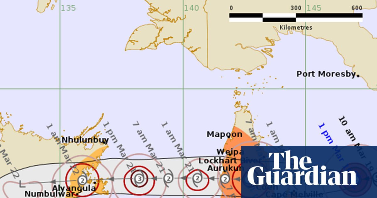
Severe Tropical Cyclone Narelle is expected to make landfall in far north Queensland on Friday morning as a monster category four storm, bringing destructive wind gusts in excess of 225km/h, according to the Bureau of Meteorology.
The severe cyclone rapidly intensified over the past 48 hours and on Thursday morning had built to a category five storm that was barrelling west, sitting about 500km east of the small town of Coen. Coen has a population of approximately 330.
If it crossed the coast as a category five, it would mark the first category five system to hit the Cape York region since Cyclone Mahina killed more than 300 people in March 1899.
Narelle will be just the fourth category five cyclone to cross the Queensland coast in a half a century, Premier David Crisafulli said.
Vulnerable residents have been evacuated, tourists have flown out on the last remaining flights and schools have been closed in the warning zone.
More than 100 emergency services personnel have been sent north, with police going door-to-door to ensure locals are prepared.
Shipping containers of supplies have arrived and emergency generators placed on standby, while the region has been told it will lose power.
Crisafulli said about eight schools – with about 780 students – were closed on Thursday and that others would probably be shut tomorrow.
BoM forecaster Angus Hines told Guardian Australia that on Thursday morning Narelle was moving “swiftly” west at about 20km/h and had experienced rapid intensification to become a category five system – the highest category available.
Speaking to reporters on Thursday, Crisafulli warned residents of the impact of strong winds, heavy rain, storm surge and flash flooding.
“I know these communities are resilient and they’ve been here before and they know what wind and a lot of rain looks like.
“This is a serious system though, and I’m asking people to take it seriously. Because it is the kind of event that doesn’t happen all that often.
“If a category five system crosses the Queensland coast, it will be just the fourth time that has happened in half a century.
“I can’t suger-coat this. The damage will be widespread.”
Early on Thursday morning, a BoM projection suggested a landfall at category five, but a later update suggested a landfall at category four – still a destructive and major cyclone. The outlooks could still change ahead of Friday’s expected landfall.
Warmer than usual ocean temperatures in the Coral Sea and its speed and favourable wind conditions “have allowed [Narelle] to intensify quickly and sit near the top of the scale”, Hines said.
Narelle was expected to make landfall on Friday morning and could bring a daily downpour of between 150mm and 300mm for the Cape York region, with up to 450mm possible in some areas.
“That is enough to cause flash flooding and cause river levels to climb so we should expect flooding as the rain works its way through the river systems,” Hines said.
Category five storms can deliver maximum winds speeds of more than 200km/h and gusts upwards of 250km/h, causing widespread destruction of buildings and vegetation.
Narelle is expected to move over the Gulf of Carpentaria before crossing the Top End on Saturday evening as a category three system.
The expected track takes the storm south of Darwin and close to Katherine and Daly River – areas that have seen devastating flooding in recent weeks.
Hines said Narelle had the potential to make a third land crossing next week after an expected move over the Indian Ocean to the west, where he said conditions were also conducive to a cyclone.
The most recent category five storm to cross the Australian coastline was Ilsa in April 2023, which struck north of Port Hedland in Western Australia and recorded a record wind gust of 289km/h.
The last time Queensland had a category five storm cross the coast was Marcia in 2015, which struck in a relatively uninhabited area north of Yeppoon.
The Queensland premier, David Crisafulli, said on Wednesday Narelle could be the biggest system in living memory for communities in the firing line.
Severe Tropical Cyclone Yasi – one of the state’s most powerful on record – struck as a category five storm in 2011, crossing further south of Narelle’s track, between Innisfail and Cardwell.
Adjunct Prof Andrew Watkins, a climate scientist at Monash University and a councillor with the Climate Council, said Narelle was moving through the Coral Sea which had seen record sea surface temperatures in recent months.
“The Coral Sea is almost half a degree warmer than it was 30 or 40 years ago. Warmer ocean temperatures are fuel for tropical cyclones,” he said.
Ocean temperatures along Narelle’s track were between 1C and 2C warmer than average, Watkins said. The Coral Sea recently recorded its hottest December, hottest February, hottest summer, hottest calendar year and hottest financial year on record, Watkins said.
with AAP
Source: https://www.theguardian.com/australia-news/2026/mar/19/tropical-cyclone-narelle-qld-storm-tracker-path-tracking-map-bom