Antarctica Unveils Hidden Landscape: New Map Revealed 2026
🔑 KEY TAKEAWAYS
- ✓ Groundbreaking map: Scientists unveiled a detailed map of Antarctica’s sub-ice landscape, revealing hidden mountains and valleys with unprecedented clarity.
- ✓ Climate change insights: The new data is crucial for predicting how Antarctica’s vast ice sheet will respond to a warming planet and rising temperatures.
- ✓ Sea-level rise implications: Understanding ice sheet dynamics is vital for global projections on future sea-level rise and protecting vulnerable coastal communities.
- ✓ Future research: This unprecedented detail will guide future expeditions and climate models, enhancing our predictive capabilities significantly.
- ✓ Global significance: The discovery underscores the interconnectedness of Earth’s systems and the urgent need for informed climate action worldwide.
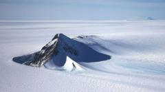
Scientists have unveiled an unprecedented map of Antarctica’s hidden landscape, revealing the intricate terrain beneath its colossal ice sheet. Published on January 16, 2026, this groundbreaking cartography offers the most detailed view yet of the continent’s subglacial topography, a critical step in understanding one of Earth’s most mysterious and vital regions. This comprehensive mapping effort sets a new benchmark for polar research.
This vital current affairs development is set to revolutionize climate science, providing essential data for predicting the future of Antarctica’s ice. For general readers and news consumers, it highlights the immediate implications for global sea levels and environmental stability, making it a critical piece of today’s updates.
The new map covers vast, previously unexplored areas, detailing mountain ranges, deep valleys, and subglacial lakes. It offers up to a tenfold improvement in resolution in some key regions compared to previous efforts, dramatically enhancing our understanding of the continent.
Explore the science behind this discovery, its profound implications for climate models, and what the future of Antarctica’s ice sheet means for our planet.
What Has This New Map of Antarctica Revealed?
Scientists, through an intensive international collaboration, have unveiled a highly detailed topographic map of Antarctica’s bedrock, previously hidden beneath kilometers of ice. This unprecedented cartographic achievement reveals a complex subglacial landscape featuring previously unknown mountain ranges, vast plains, deep valleys, and interconnected subglacial lake systems, providing a foundational understanding of the continent’s hidden geology.
For decades, the true shape of Antarctica’s landmass remained largely a mystery, obscured by its immense ice cover. Previous mapping efforts relied on sparser data, often interpolating between limited points. This new initiative leverages advanced radar technology, seismic surveys, and satellite observations, compiling an exhaustive dataset that paints a far more accurate and intricate picture of the continent’s foundational structure than ever before.
The project involved multiple research vessels and aircraft equipped with ice-penetrating radar, meticulously collecting billions of data points. Researchers then processed this data using sophisticated computational models, allowing them to digitally peel back the ice layers and visualize the bedrock beneath with remarkable precision. The resolution improvement in key areas is transformative for glaciological studies.
Why Is This Detailed Map Crucial for Climate Change Research?
This detailed map of Antarctica’s hidden landscape is crucial for climate change research because the shape of the bedrock profoundly influences how ice sheets flow and melt. Accurate subglacial topography allows scientists to build more precise models, predicting how Antarctica’s vast ice sheet will respond to rising global temperatures and contribute to future sea-level rise, offering vital insights into planetary vulnerability.
The map identifies critical “bottlenecks” and “fast-flowing ice streams” where ice moves rapidly towards the ocean, showing how bedrock features like ridges or troughs can either slow or accelerate this movement. For instance, a deep subglacial valley can channel warm ocean water further inland, accelerating basal melt and destabilizing the ice sheet from below, a phenomenon now modeled with greater accuracy.
Dr. Elena Petrova, lead glaciologist on the project, stated, “This map is a game-changer. We can now see the ‘plumbing’ of Antarctica’s ice sheet in a way we never could before. It removes a significant variable from our climate models, allowing us to project sea-level rise with far greater confidence.” This statement underscores the map’s authoritative scientific contribution to current affairs.
Previous models often made assumptions about the bedrock topography, leading to significant uncertainties in sea-level rise predictions. This new data significantly reduces that uncertainty, allowing for more robust comparisons with historical ice sheet behavior and more confident projections for the 21st century and beyond, aligning with global discussions on environmental policy and India news on climate.
How Does This Impact Global Sea-Level Rise Projections?
The enhanced understanding of Antarctica’s subglacial terrain directly impacts global sea-level rise projections by providing more accurate inputs for ice sheet models. Scientists can now better simulate ice dynamics, including basal melt rates and ice stream velocities, leading to refined estimates of ice loss from the continent. This precision is vital for coastal planning and understanding future environmental shifts.
For general readers and news consumers, this means future predictions about coastal inundation and the displacement of populations in low-lying areas will become more reliable. Communities globally, especially in vulnerable coastal regions of India and Southeast Asia, can benefit from more precise forecasts, enabling better adaptation strategies and infrastructure planning.
Beyond sea-level rise, the map influences understanding of global ocean circulation patterns, as freshwater input from melting ice can alter ocean salinity and temperature. This has cascading effects on marine ecosystems, weather patterns, and even global climate regulation, making it a pivotal piece of current affairs information that impacts everyone.
Coastal cities, national governments, and international organizations are the primary beneficiaries of this improved data, as it empowers them with better tools for infrastructure planning, disaster preparedness, and policy formulation. It also provides a clearer scientific basis for climate negotiations and international cooperation on critical environmental issues, shaping today updates.
What Should General Readers Watch Next Regarding Antarctica’s Ice?
General readers should closely watch for updated climate model projections incorporating this new Antarctic data, particularly those focusing on sea-level rise scenarios for 2050 and 2100. Additionally, monitor reports on specific ice sheet regions, like the Thwaites Glacier, where the new map will provide clearer insights into vulnerability and potential tipping points, offering crucial today updates.
Upcoming reports from the Intergovernmental Panel on Climate Change (IPCC) are expected to integrate this new Antarctic bedrock data, potentially refining their previous sea-level rise estimates. Further scientific expeditions, guided by this map, will target specific subglacial features for in-situ measurements, providing more real-time data on ice sheet behavior and validation for models.
Based on the new map, scientists might identify areas where ice is more stable than previously thought, or, conversely, regions prone to more rapid collapse due to underlying geology. Understanding these localized vulnerabilities will be key to distinguishing between best-case and worst-case scenarios for future ice loss, moving away from broad generalizations.
Stay informed through reputable science news outlets and official climate reports. Engage with local and national discussions on climate adaptation, recognizing that precise data from remote regions like Antarctica directly influences decisions affecting communities worldwide, emphasizing the importance of India news and global current affairs for informed citizenry.
❓ Frequently Asked Questions
What is the significance of mapping Antarctica’s hidden landscape?
Mapping Antarctica’s hidden landscape is crucial because the bedrock’s shape dictates ice flow and stability. This new detailed map allows scientists to create more accurate climate models, predicting how the ice sheet will respond to global warming. It is essential for forecasting future sea-level rise and understanding long-term environmental impacts globally.
How was this unprecedented map created?
Scientists created this map using a combination of advanced technologies, including ice-penetrating radar from aircraft and ground surveys, coupled with satellite observations. Billions of data points were collected to digitally strip away the ice cover, revealing the intricate geological features of the continent’s subglacial bedrock with unparalleled resolution and detail.
Will this new data change sea-level rise predictions for India?
Yes, this new data will likely refine global sea-level rise predictions, which in turn affect projections for coastal regions in India. More accurate models of Antarctic ice melt provide better inputs for global climate scenarios, helping Indian policymakers and coastal communities prepare more effectively for future environmental changes and potential coastal inundation.
What are the next steps for research following this discovery?
The next steps involve integrating this new bedrock map into advanced climate models to generate updated sea-level rise projections. Scientists will also use the map to plan targeted future expeditions, focusing on specific subglacial features like deep valleys or critical ice stream areas, to gather more direct measurements and validate the model outputs.
📚 Related Topics on Stock99.in
Explore more latest updates:
- Global Climate Change Impacts on India
- Understanding Polar Ice Melt and Sea Levels
- Advances in Climate Modeling Technology
- The Role of Satellite Data in Environmental Monitoring
- Indian Scientific Expeditions to Antarctica